Oatman is a fun town to visit on Route 66 and one that you don’t want to miss if you’re trying to experience the entire Route.
There are several historic old buildings, wild burrows that roam the streets, a wild west gunfight in the street every day, lots of photo opportunities, a hotel wall-papered with dollar bills where rumor has it that Clark Gable and Carole Lombard spent their honeymoon. There are lots of gift and souvenir stores and other places to shop.

We had breakfast at the Oatman Hotel Restaurant and while there, I was told by different people that there is between $70,000 and $300,000 in one dollar bills stapled to the walls of the restaurant in the Oatman Hotel and you’ll find out why below.
Oatman is located along the longest continuous stretch of original Route 66 in the US. It’s 28 miles east of Kingman and 22 miles from Needles on the west side. It’s a small village in the Black Mountains of Mohave County, Arizona.

At one time it was legitimately described as a ghost town and once had a population in excess of 10,000 residents.
Facts & Weather
Elevation – 2,710 Feet
Population – 43 (2019)

The elevation of Oatman is 2,710 feet. It’s located in the Black Mountains of Mohave County, AZ. If you’re visiting in the summer time, expect it to be hot. The average day time temperatures between June and September are around 102 degrees. Average lows are in the low 70’s at night. Temperatures in the Winter vary between lows of 40 degrees to average day time temperatures in the mid 50s to mid 60s.
See Oatman Montly Weather Averages for more details.
History of Oatman

The name Oatman comes from the name of a young girl who was traveling with her family during their journey to the West. Olive Oatman was kidnapped or captured by Indians when they massacred her family in 1851. She was sold or traded to another tribe, the Mohave Indians, who adopted her and tattooed her face with the customary markings of the tribe. She was finally released in 1856. In honor of her, the town was named Oatman.
Gold was first discovered in Oatman in 1863. For the next fifty years, mining increased and decreased in the remote area until new technology, lower transportation costs, and new gold discoveries brought booming prosperity to Oatman in the early 20th century.
The opening of the Tom Reed mine along with one owned by the United Eastern Mining Company led to one of the largest gold discoveries in 1915. That led to a boom for the town from 1915 to 1917. The mines in Oatman were some of the largest producers of gold in the American West for about a decade.
A fire in 1921 destroyed much of the town but not the Oatman Hotel which was built in 1902 and is the oldest two-story adobe structure in Mohave County.
United Eastern Mines shut down its operation in Oatman in 1924 after producing a little over $13 million in gold at the government controlled market price of $20 per ounce. By 1941, Oatman area mines had produced over $40 million dollars when the remainder of the town’s mining operations were ordered shut down by the government as part of the country’s war effort and the need to focus on production of other metals that were needed.


If it wasn’t for the fact that Oatman was located on busy U.S. Route 66, it might have become a ghost town. Fortunately with the growing amount of traffic on Route 66 between Kingman, AZ and California, the town was able to shift it’s business focus from mining to catering to the travelers driving through town on the busy highway. That advantage, however, was soon to go away because a new Interstate Highway was to open in 1953 that would completely bypass the town of Oatman. With all of the traffic diverted to the new highway, Oatman was all but abandoned in the early 1960’s.
The town became a ghost town until the 1990’s when the resurgence in popularity of Route 66 brought a lot of tourists through town.
Tom Reed Mine
In 1900 prospector Ben Taddock was in the area and discovered a new vein of gold ore. The mine produced over $3 million worth of gold. Once it was made public that gold had been found, more miners and prospectors arrived in the area. Then in 1904, the Tom Reed vein was discovered and soon became known as the Tom Reed Mine and run by the Tom Reed Gold Mining Company.
The Tom Reed claims were sold to a group of investors in 1908 and they began production of a high grade of ore. The mine produced millions of dollars in gold and silver ore in the beginning. By this time, Oatman had a population of several thousand people.
After a few years, the production at the Tom Reed mine slowed and became sporadic. Soon after another group of miners put down a shaft in another area and opened a mine called the United Eastern Mining Company. That was followed by another mine called the Big Jim Company. Those three mines all working on the Tom Reed Vein became the largest and wealthiest mines producing almost $36 million worth of gold. The Tom Reid mine was the greatest of the three producing more than $13 million in gold and silver.
Then the depression in the 1930’s made operation of the mines unprofitable. The United Eastern Mine and Big Jim Mine closed in 1924 and the Tom Reed Mine closed in 1932.


Tom Reed Mine Today – Street View on Google Maps
The main street through Oatman is the Route 66 highway and extends about four tenths of a mile from one end to the other. Depending on the time of the year you visit Oatman, the town could be packed with tourists… cars, trucks, motorcycles can line the streets from one end of town to the other. There is a parking lot at one end of town and it could also be full of tour buses.

Oatman has largely been recreated as a tourist town taking advantage of the increased interest in Route 66. The street is lined with gift shops offering all sorts of merchandise and Route 66 memorabilia.

The Oatman Hotel
The Oatman Hotel is the oldest two-story adobe structure in Mohave Counte and a Mohave County Historical Landmark. It was built in 1902 and was originally called the Drulin Hotel. It was renamed the Oatman Hotel in the mid 1960’s. In 1921, a fire burned down most of Oatman’s smaller buildings, but the Oatman Hotel survived. It originally had only eight rooms and served local miners in the area.

It no longer offers overnight accommodations for guests, there are rooms full of gifts and souvenirs on the top floor and a bar and restaurant on the first floor.
It is famous for a Hollywood couple who spent their honeymoon there. It’s rumored (but can’t be verified) that Clark Gable and Carole Lombard stayed their after their wedding in Kingman on March 18, 1939. Their “honeymoon suite” has been restored to the time period and is one of the hotel’s major attractions.
The walls of the restaurant and bar are lined with thousands of one dollar bills that are dated and signed and have been stapled to the walls by guests, a practice that started when miners would come to the bar and attach a few bills to the wall so they always had a way to pay for their meal or drink when they came to the bar.
Shopping on Mainstreet in Oatman
The Ore House
195 Oatman
928-768-3839
Jack Ass Junction
219 Main St.
Oatman, AZ 86433
928-768-8190
Main Street Emporium
140 Main Street
Oatman, AZ 86433
928-768-1321
From their website, the Main St. Emporium, owned and operated by artists, Don and Shirle Burrous, offers a unique assortment of hand-crafted items, all one-of-a-kind and made locally.
Wall art ranges from desert wild life forms of quail and roadrunners, burros and horses, lizards and birds up to steer heads and rope arts. A walk through the beaded curtains reveals the Candle house where candles of many scents and colors can be found. New items are constantly being added and no two are ever exactly alike.
Fast Fanny’s Place is located at:
141 Main Street, Oatman, AZ 86433.
928-768-7400
Fast Fanny’s Place is your source for turquoise and silver jewelry and a lot more. It is a Family run business, for over 30 years. They sell turquoise and silver jewelry, wind chimes, Oatman postcards, and much more.
The Oatman Gift Shack is located at:
221 Main St. Oatman, AZ 86433
928-768-8433
Dakota Leather
& Gifts is located at:
220 Main St., Oatman, AZ 86433
928-768-2597
The Oatman General Stores is located at:
180 Main St., Oatman, AZ 86433
928-768-9448
From their website,the Oatman General Store is owned by a couple who, years ago, decided to pack up their belongings and find a place to retire. They followed Route 66 and made it to Oatman and ran out of gas. They stayed the night and that was years ago. They purchased the Oatman General Store and started with a small inventory of hot sauces and groceries. Today, they carry over 100 kinds of hot sauces. They also have a large collection of Coca Cola collectibles and tones of Arizona, Route 66, and Oatman souvenirs, novelty items and Christmas ornaments. Over the years, they have expanded their selection and now carry Black Hills Gold jewelry, and genuine American Indian made jewelry and artifacts.
According to the previous owner, the Oatman General Store has been around for over 100 years. It was originally called the Central Commercial and sold everything from groceries to building materials and blasting powder for the mines. During the Gold Rush days there were approximately 10,000 people living in Oatman.
The Class Ass is located at:
191 Main Street, Oatman, AZ. 86433
928-788-1885
From information on their website… The Classy Ass Gift Shop is owned and operated by Judy and Jerry Live. They came to Oatman and fell in love with the beautiful mountains and the peace and quiet of the desert, and decided to make a life-style change. They left the big city and have been in Oatman for the past twenty years. Everything in their shop is Made in America and you’ll find everything from jewelry to paintings and other one-of-a-kind gifts.
The Drive Between Kingman and Oatman

Oatman is about 38 miles west of Kingman, AZ on Historic Route 66 (AKA Oatman Highway) but because a good portion of the road is a very narrow windy road with a lot of curves and switch backs, it takes hour to an hour and a half to make the drive. The last 23 miles from Cool Springs to Oatman is the really windy part.

On the way there, we saw some beautiful scenery and a few cows and a bull within feet of the road.
Cool Springs

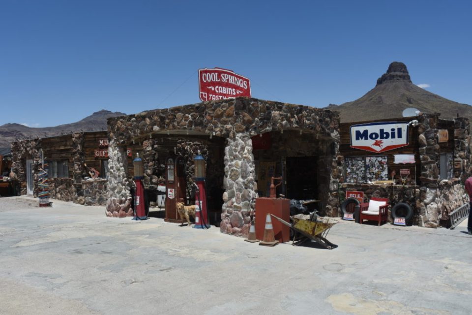
Just before the road climbs up a windy stretch into the Black Mountains toward Oatman, you’ll see Cool Springs. It opened as a Mobil gas station in 1927 and later expanded to include eight tourist cabins. With all of the travel on Route 66, it flourished through the World War II years. As more and more people acquired automobiles and took to the highways, Cool Springs entered its golden years after the war. Cool Springs was the last stop on Route 66 before heading into the dangerous mountain road toward Sitgreaves Pass and on to Oatman so it was a popular place to fill up with gas, check the radiator, and stretch your legs before traveling on.
Unfortunately, in the mid 1950’s, this section of Route 66 was bypassed by a straighter new alignment of Route 66 that went through Yucca, Arizona and did away with the need to travel up the steep mountain grades of Sitgreaves Pass. This would eventually be the path that the new Interstate 40 would follow and as it did, so did the traffic that used to go through Cool Springs. When the new alignment opened, the busy days at Cool Springs declined.
Then in 1966, a fire burned Cool Springs to the ground. The only thing that remained was parts of the stone foundation and the original stone pillars. For the next 25 years, Cool Springs was a ruin by the side of the road.

In the 1990’s, a new interest in Route 66 had begun and there were more and more travelers that would prefer to take the old two-lanes of Route 66 than zip by all of the small stops that the Interstate offered.

In 1997, a gentlemen named Ned Leuchtner passed through the area and became interested in Cool Springs and its history. He contacted the owner of the property and for three years he tried to purchase it but to no avail. Finally, in 2001, he was able to purchase the property and the rebirth of Cool Springs had begun.
Cool Springs Then and Now
Ruins of Old Miners Cabin

On the way to Oatman from Kingman and just before you get to mile marker 30, there are about 30 steps carved into a rocky hillside on the left. They lead up to the Shaffer Fish Bowl Spring which is a natural spring that collects in a concrete bowl surrounded by greenery. It’s called the fish bowl because it is apparently often stocked with goldfish by local residents who know of its existence.
The pool is not visible from the road and it’s easy to miss, but there is a small place to pull over and park so you can climb the steps and take a look.
A man named Shaffer created the concrete bowl in the 1930’s as part of the Works Progress Administration (WPA) after noticing water cascading down the cliff walls. He found the spring and to take advantage of the resource, he built a basin of stone and concrete to collect the water in a small pool. With the greenery surrounding it, it has become a tiny oasis in the middle of the desert.
This “oasis” became a place for weary traveler’s and animals alike as they passed through this part of the desert.
See the article from the Kingman Daily Miner – Shaffer Spring, or the Gold Fish Bowl, worth exploring.

The summit at Sitgreaves Pass is at an elevation of 3,556 ft. Just past the sign is pull off where there is a wonderful view of the mountains and the valley below. You’ll also see how windy the road is as you travel down into the valley. Also at the pull off there are remnants of the foundation of a building that once served as a gas station and ice cream shop.

The Oatman Burrows
The burro played a varied and extremely critical role in Oatman’s mining history. They are extremely strong and sure footed and carried everything the miners and prospectors needed from gold ore, equipment, machinery parts, long steel cable and of course their owner.

Early day prospectors would go weeks and occasionally even months without seeing another human being and a bottle of whiskey was a poor substitute for sitting alone on the side of some mountain. Many miners and prospectors had a true friend in their burro. A friend that was so loyal and hard working, so tough and so strong and often so reciprocal that their relationship passed the bounds of simple friendship. This friend was their burro.

Miners often became so attached to their burros that they frequently shared their beans and biscuits and in return they were a loyal friend who always seemed to make sure their owner somehow made it up the next hill.

In 1942, the government shut down the last of the surviving mines as non essential to the war effort. The burros first came to Oatman in the early 1900’s with early day prospectors. The animals were also used inside the mines for hauling rock and ore. Outside the mines, they were used for hauling water and all the other supplies that the miner needed. As the mines closed and people moved away, the burros were released into the surrounding hills.
The wild burros in Oatman today are descendants of those burros from the heyday of mining near Oatman.


